Your Online Guide to Padstow, North Cornwall - Beaches

Attractions | Beaches | Camel Trail | Self Catering | Bed & Breakfast | Map
Your Online Guide to Local Beaches
Padstow, North Cornwall
This section of the North Cornwall coastline offers some fantastic beaches for families and surfers alike. The beaches of Polzeath and Harlyn Bay are particularly popular with surfers. The bustling fishing port of Padstow with its many top quality fish restaurants, including those of Rick Stein offers regular ferry trips across the Camel Estuary to the affluent village of Rock with its popular sandy beach.
| Polzeath | |
|
A large, west facing, bay of flat golden sand. Popular with surfers
and bathers and is regularly cleaned. Easily accessible from |
|
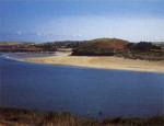
| Daymer Bay | |
 ~
Car Park ~ Toilets ~ Refreshments ~
Car Park ~ Toilets ~ Refreshments ~ Dogs allowed A west facing, ½ mile stretch of fine sand, surrounded by
sand dunes. Attractive views across the Camel Estuary. Adjacent
to golf course and close to the 15th century St Enodoc church. |
|
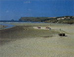
| Rock | |
|
A continuation of Daymer Bay. West facing, sandy beach on the Camel
estuary, surrounded by sand dune system. Easy level access from
car park. Can become very crowded in summer. |
|
| St George's Well | |
|
Padstow's two closest beaches are St George's Well, which has a
good area of sand even at high tide, and Harbour Cove, a long stretch
of golden sand backed by dunes. |
|
| Trevone Bay | |
|
An attractive west facing beach, located to the south of Trevose
Head and to the north of Harlyn Bay. A small but pupular holiday
destination, with large areas of golden sand. |
|
| Harlyn Bay | |
|
A sheltered, north facing stretch of soft golden sand, even at
high tide. Surrounded by small sand dunes. Easy level access. |
|
| Constantine Bay | |
|
A large, west facing stretch of fine golden sand. Surrounded by
sand dunes which offer shelter from the wind. Easily accessible. |
|
| Treyarnon Bay | |
|
A west facing beach of soft, golden sand and rock pools. Popular
with families. Easily accessible from car park via a slipway. |
|
| Porthcothan Bay | |
|
The sandy beach at Porthcothan is located south of Constantine
Bay. There is plenty of parking although at high tide the area of
sand on the beach is restricted. |
|
| Mawgan Porth | |
|
Large, west facing cove situated between two steep headlands where
a river enters the sea. Popular family beach with flat sand at all
tides. Accessible for pushchairs with a little effort. |
|
 ~
Car Park ~ Toilets ~ Refreshments
~
Car Park ~ Toilets ~ Refreshments 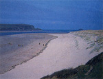 ~
Car Park ~ Toilets ~ Refreshments
~
Car Park ~ Toilets ~ Refreshments 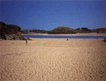 ~ All facilities in Padstow ~
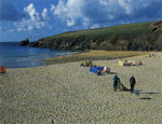 ~
Car Park ~ Toilets ~ Refreshments
~
Car Park ~ Toilets ~ Refreshments 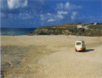 ~
Car Park ~ Toilets ~ Refreshments
~
Car Park ~ Toilets ~ Refreshments 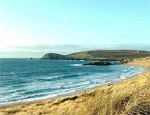 ~
Car Park ~ Toilets ~ Refreshments
~
Car Park ~ Toilets ~ Refreshments 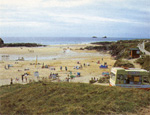 ~
Car Park ~ Toilets ~ Refreshments
~
Car Park ~ Toilets ~ Refreshments 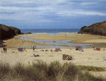 ~
Car Park ~ Toilets ~ Refreshments
~
Car Park ~ Toilets ~ Refreshments 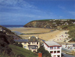 ~
Car Park ~ Toilets ~ Refreshments
~
Car Park ~ Toilets ~ Refreshments